DJI SDK 5.13 & Maven EVO 2.0 roadmap

🚀 Great news for DJI Mini 4 Pro pilots! 🚀

DJI has just released SDK 5.13, bringing official support for the Mini 4 Pro! 🎉

This means an update for Maven EVO is coming soon, adding full compatibility with the Mini 4 Pro.

🔜 Maven EVO Roadmap for DJI Mini 4 Pro Support 🚀

We’re working hard to bring Maven to the DJI Mini 4 Pro, and here’s our roadmap:

Step 1: We’ve ordered a Mini 4 Pro with DJI RC-N2, which is required for third-party apps. This is the first step toward full compatibility.

🛠 Step 2 (1-2 weeks): The first Maven update will roll out, bringing full support for the Mini 4 Pro with all the powerful features from Maven EVO, including:
🔹 GPS Follow
🔹 VR Mode
🔹 Waypoint Missions (Virtual Stick)

🚀 Step 3 (Another 1-2 weeks): A second update will add full support for Onboard Waypoint Missions, unlocking even greater mission planning capabilities!

Stay tuned for more updates – the wait won’t be long! 🔥

#Maven #MavenEVO #DJIMini4Pro #WaypointMissions #VRMode #DronePilots


📢 Update 31/03/2025: Maven EVO 2.0 is live!
Packed with new features and full Mini 4 Pro support — check out the full blog post here

Maven: Next-Level Mission Planning with 3D Previews & KML Export!

🚀 New Features

🔹 Advanced Mission Planning Tools:

🎥 3D Flight Preview for Realistic Mission Simulation (In-App)

A game-changing feature! The 3D flight preview allows you to visualize the drone’s behavior during the mission execution in real-time.
✅ An essential tool to verify mission settings before takeoff and prevent mistakes.
✅ The simulation runs in real-time, accurately reflecting speed and mission parameters.
✅ You can speed up playback, pause, and scrub forward or backward.
✅ The drone’s position remains visible on the map throughout the preview.

🌍 Mission Export to KML for Google Earth and Earth Pro
For an even more immersive experience, you can now export your mission in KML format and open it in Google Earth.
✅ The KML file includes the flight animation, POI placemarks, and the mission path polyline.
Note: Google Earth (mobile app) and Google Earth (web) do not support automatic flight animations.
✅ To view the full mission flight animation, use Google Earth Pro on PC or Mac (available for free download).

📡 Drone Field of View (FOV) Visualization on the Map
Now, when setting a waypoint, you can instantly see the area that the drone will capture. This helps you plan your shots better and avoid unexpected surprises during the flight.

🔹 More Precise Exposure Control:
📸 Manual shutter speed selection for better control over your shots.
📷 Improved manual ISO selection to optimize exposure in all lighting conditions.

🛠 Improvements & Optimizations:
✔️ Various bug fixes and performance optimizations for a smoother and more stable experience.

💡 We’ve worked hard on this update, and we’re thrilled to share it with you! We can’t wait to hear your feedback—let us know what you think!

Enjoying this free update? Please consider leaving us a 5-star rating on Google Play Store! 🌟 to show your appreciation. 
Your support helps us reach more drone pilots like you and continue improving the app. 🚀

📝 Notes

🚀 The new Mission Preview feature is already available in Maven 3.15 (iOS), Maven 2.2 (Android) and Maven EVO 1.2 (Android).

⚠️ Mission Preview Limitations:
🔸 The preview cannot tilt the camera above the horizon. If such movement is programmed, the preview will still be locked at the horizon.  However, in the actual mission, if the drone supports it, it will look up as expected.
🔸 The preview does not simulate waypoint actions, such as gimbal or drone rotations.
🔸 Real-world factors may cause differences between the simulation and actual flight execution

🚀 Maven EVO 1.2.1 is here! 🎉

  • Added white balance settings
  • Added exposure compensation settings

Update now and enjoy more control over your camera! 📷✨

🔗 Update now!

#MavenEVO #DroneApp #Update

Maven 3.11 – New Drones Supported

This update is focused on supporting new drones
-DJI Mini 2
-DJI Air 2S
-DJI Mini SE

All functions of the app are available with the new drones

Added on-screen Exposure Lock Button 

Small bug fix and performance improvements

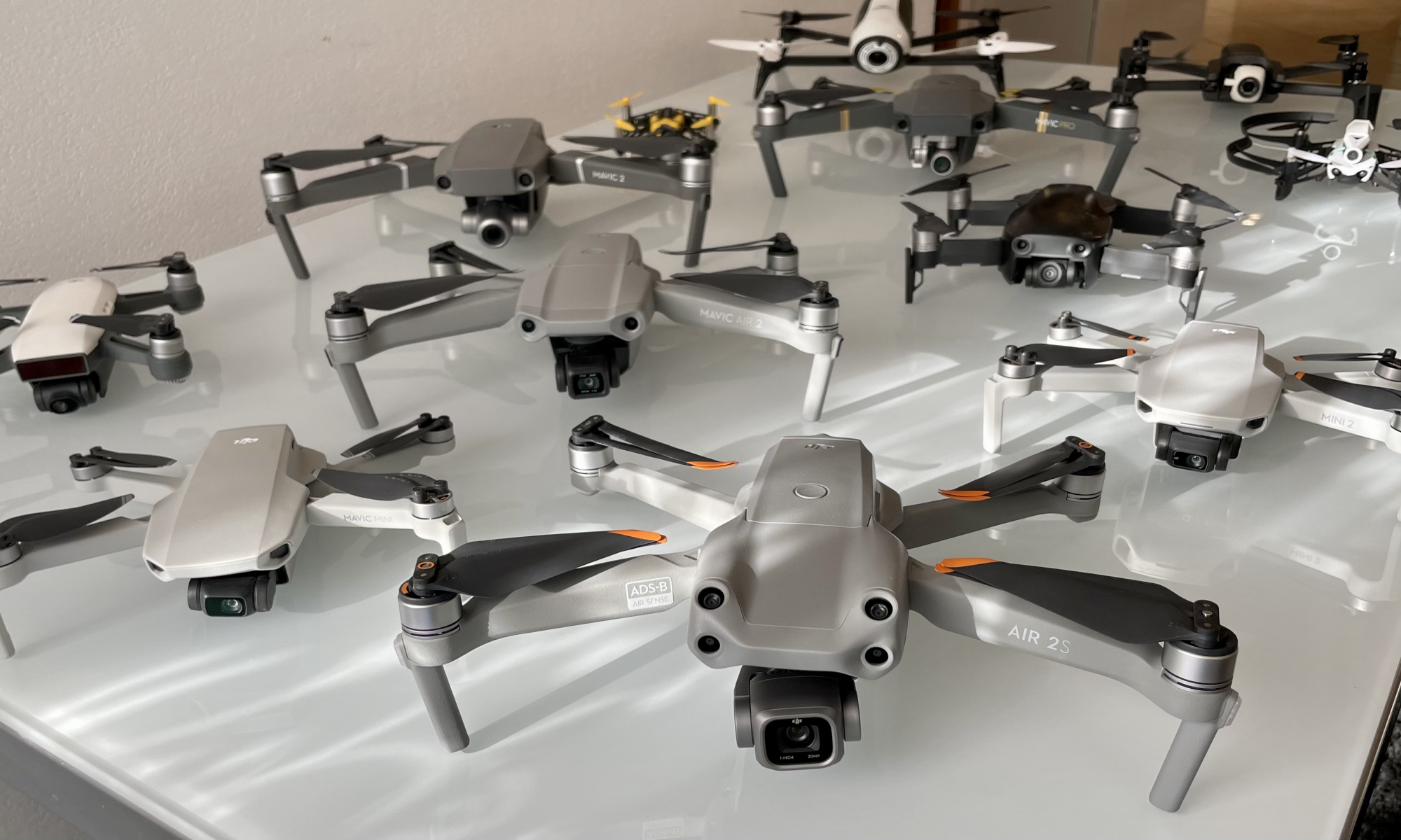
For sure this is the most anticipated update ever, Mini 2 owners are so many! and this puts us in front of a huge amount of new potential customers that we already welcome.

We are really excited about this update but it doesn’t stop us from working on future developments right now.

I invite all new customers to watch this video to get a small preview of the potential of the app, and then visit the tutorial section of the site.

If you are new to Maven, I inform you that there is a group on FB where to discuss, exchange information and useful tricks on how to use Maven or simply share your own videos made with Maven. https://www.facebook.com/groups/938321600163115/

or check the official Maven FB page to stay up to date on upcoming updates! https://www.facebook.com/mavenPilot

Here all supported Drones:

  • Mavic Mini
  • Mavic Mini 2
  • Mavic Mini SE
  • Mavic Air
  • Mavic Air 2
  • Mavic Air 2S
  • Mavic 2 Pro
  • Mavic 2 Zoom
  • Mavic 2 Enterprise
  • Mavic 2 Enterprise Dual
  • Mavic Pro
  • Mavic Pro Alpine
  • Mavic Pro Platinum
  • Spark
  • Phantom 3 series
  • Phantom 4 series

Previous Update 3.10

Maven 3.9 – orbit and spirals

This Maven update brings a feature to automatic missions that will make your head spin !!

Now there is the possibility to turn any waypoint into an orbit or spiral! check out this video tutorial we have prepared! and to follow the entire change log of the update!

change log:

  • Mission Planner Improvements:
    • add the possibility to transform any waypoint into an “orbit waypoint”
    • modifying the parameters of the “orbit waypoint” you can create any orbit or spiral in your autonomous mission
    • orbit parameters:
      • radius
      • number of laps
      • final radius
      • final height
    • add the possibility to transform a waypoint into a POI
    • added the possibility to assign tags to the mission to classify it, there are predefined tags and the user can add other customized ones
  • Improvements to the “by flight” function:
    • now you can save POIs
  • Improvements to the mission list:
    • sorting
      • now you can choose to sort the list by modification date, mission name or mission location.
    • filter
      • now it is possible to filter the list of missions by tags or by mission location
  • Minor improvements to the graphical interface
    • (who doesn’t like rounded corners?)
  • recompiled for full compatibility with iOS 15
  • other small improvements under the hood to make it more responsive and ready for future updates

shot with Nikon D5300 – exposure time 30s – Drone Mavic 2 Zoom

Uploading Flight Logs to AirData UAV

Overview

Every professional drone pilot understands the importance of having good quality post-flight logs at their disposal at all times.

They serve not only as analytical data to understand the events that unfolded during flight, but also as historical record of flights in compliance with regulations and predictive maintenance of onboard components & batteries.

How to configure log synchronization with AirData UAV

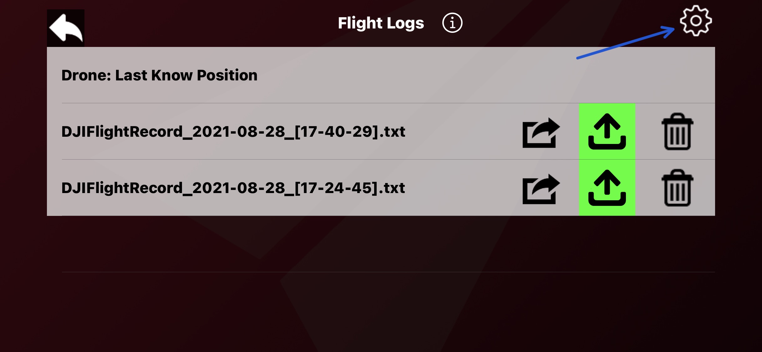
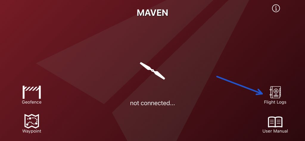
to start enter the flight logs section from the main screen of the app..

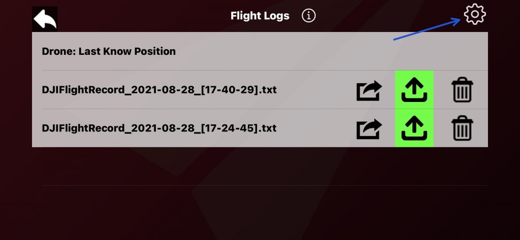
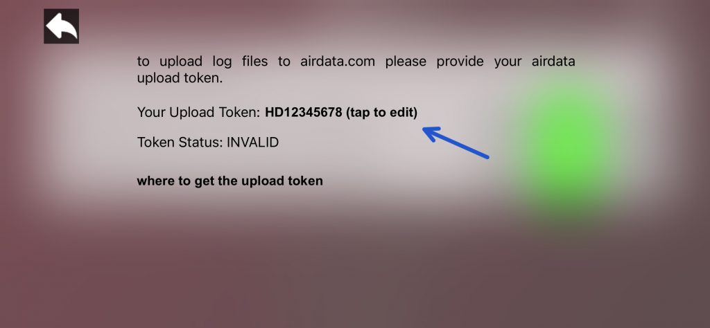
tap on settings…

enter your AirData upload token and that’s it

where retrieve the upload token

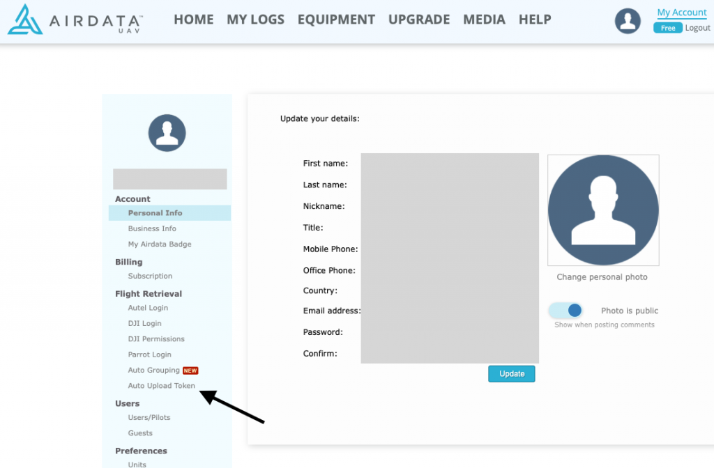
go to airdata.com and log in, the click on “My account”

click on Auto Upload Token

here you AirData Upload Token

If you are logged in on airdata.com you can just follow this link to go the Upload token page: https://app.airdata.com/main?a=account&apage_id=auto_upload_token

How upload Flight Logs to AirData.com

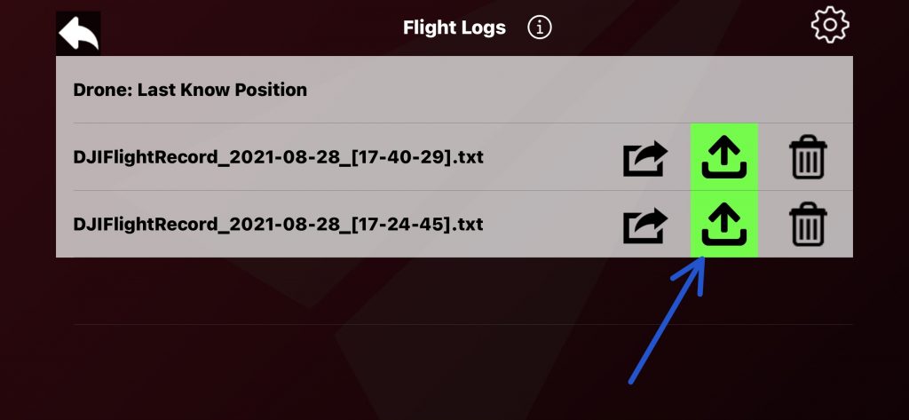
once your upload token is configured, simply tap the upload button to sync the desired logs with airdata.com

Maven 3.8 – Elevation API

Maven app has just been updated again.
In this update we have included 2 new features that will greatly help you plan your mission
1) Above ground (altitude option)
2) define Mission “by Flight”

both new functions will help you define the mission where the heights of the terrain or the object you want to shoot are unknown to you.

Above the Ground:

(beta preview, the actual version my be different)

The elevation information is taken from different internet database

Main Elevation Data Provider:

DEM Net Elevation API ( https://elevationapi.com )

using these digital elevation models:

NASADEM – https://doi.org/10.5067/MEaSUREs/NASADEM/NASADEM_HGT.001\

RTM_GL1 OpenTopography – https://opentopography.org/

“by Flight” Tutorial

Complete Maven 3.8 change log:

  • Added “Above The Ground” altitude option
  • Added the ability to save waypoints directly from the drone position
  • Added “+” annotation before first waypoint and after the last waypoint for faster mission modification
  • Added a label with the distance to the POI in the waypoint settings
  • Added a button to change the map from standard images to satellite images in mission settings
  • Improved the responsiveness of the app when adding waypoints
  • Increased responsiveness when selecting waypoint with a tap
  • Fixed an issue that can sometimes cause too loud sound to be played when a waypoint is added
  • Fixed an issue that caused the drone to remain hovering at the first waypoint in some situations